Weston Favell (Greenways)

Address: 142 Boronia Road, Vermont
The historic homestead of 'Weston Favell', or 'Greenways' as it was later referred, was built circa 1883 on a 25 acre property located at present-day 142 Boronia Road, Vermont, acquired by George Augustus Goodwin in 1877.
|
|
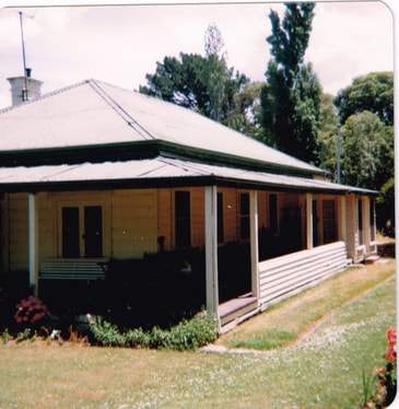
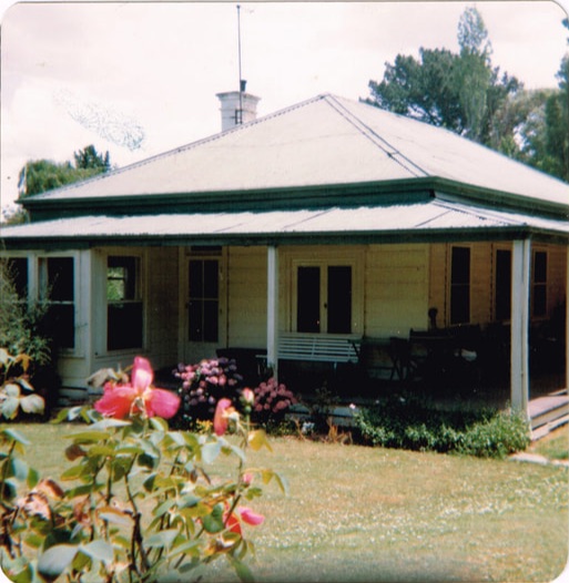
'Greenways' as photographed by Tim Shambrook in 1983. Photographs courtesy of Tim Shambrook. |
George Augustus Goodwin, born in 1848, was a real estate agent, farmer and former councillor for the Shire of Bulleen, whom in 1874, had successfully obtained a Crown Grant for the Boronia Road property. By May 1st, 1877, Goodwin had obtained a full title to the land and proceeded arrange for the construction of a dwelling on the property for himself and his wife, Annie. Prior to the Goodwin's ownership, the property had formed part of 'Crown Allotment 122' in the Parish of Nunawading which had accommodated a cattle pound located near the Dandenong Creek.
Land in the Parish of Nunawading was first offered for sale in 1855 and 1856 (Brennan, 1972). However, during this time, much of the land now known as Vermont remained unsold. Some of the remaining portions were acquired by speculators, such as the prominent medical doctor and parliamentarian, Dr. Louis Lawrence Smith, among others, who proceeded to divide their allotments into small farms (Brennan, 1972). In the meantime, the discovery of gold in Victoria in 1851 brought further development to the Nunawading area. The enactment of the 42nd Clause of the ‘Amending Act of 1865’ (also known as ‘The Grant Act’) was intended to afford miners facing hardship the opportunity to establish themselves on land near to the goldfields by allowing individuals to acquire up to 80 acres of land across four licenses within ten miles, and later expanded to thirty miles, of a gold field (Brennan, 1972). After gold was found at nearby Anderson's Creek in Warrandyte, vast numbers of settlers, who came to be known as '42nd selectors', were able to acquire land in this manner in Nunawading. One of these individuals was Isaac Moore, who by 1878, was the registered owner of a 76 acre property adjacent to the Goodwin's.
Land in the Parish of Nunawading was first offered for sale in 1855 and 1856 (Brennan, 1972). However, during this time, much of the land now known as Vermont remained unsold. Some of the remaining portions were acquired by speculators, such as the prominent medical doctor and parliamentarian, Dr. Louis Lawrence Smith, among others, who proceeded to divide their allotments into small farms (Brennan, 1972). In the meantime, the discovery of gold in Victoria in 1851 brought further development to the Nunawading area. The enactment of the 42nd Clause of the ‘Amending Act of 1865’ (also known as ‘The Grant Act’) was intended to afford miners facing hardship the opportunity to establish themselves on land near to the goldfields by allowing individuals to acquire up to 80 acres of land across four licenses within ten miles, and later expanded to thirty miles, of a gold field (Brennan, 1972). After gold was found at nearby Anderson's Creek in Warrandyte, vast numbers of settlers, who came to be known as '42nd selectors', were able to acquire land in this manner in Nunawading. One of these individuals was Isaac Moore, who by 1878, was the registered owner of a 76 acre property adjacent to the Goodwin's.
Previous Owners
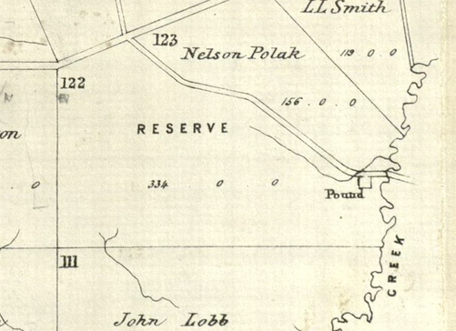
Reserve as Crown Allotment 122 in the Parish of Nunawading
In 1864, the land on which 'Weston Favell' was situated was bounded on three sides by Moore Road, Boronia Road and the Dandenong Creek and formed part of Crown Allotment 122 in the Parish of Nunawading.
Reserve as Crown Allotment 122 in the Parish of Nunawading
In 1864, the land on which 'Weston Favell' was situated was bounded on three sides by Moore Road, Boronia Road and the Dandenong Creek and formed part of Crown Allotment 122 in the Parish of Nunawading.
Parish of Nunawading Map 1864. |
George Augustus Goodwin and Annie Goodwin (1874-1884)
George Goodwin was a real estate agent, farmer and former councillor for the Shire of Bulleen who obtained a full title to the property on May 1st, 1877. George's wife, Annie, was an experienced judge of cattle (Shambrook, 2010).
George Goodwin was a real estate agent, farmer and former councillor for the Shire of Bulleen who obtained a full title to the property on May 1st, 1877. George's wife, Annie, was an experienced judge of cattle (Shambrook, 2010).

Parish of Nunawading Map 1878. |
Henry Yeo (1884-1888)
Henry was a builder by trade and owned the property for a period of four years (Shambrook, 2010).
Ernest Alfred Plumridge and family (1888-1920)
The Plumridge family established a flower farm on the property and subsequently subdivided the original 25-acres into two allotments of 11 and 14 acres, respectively, although some records indicate they were instead parcels of 12 and 13 acres (Shambrook, 2014). With an occupation as florist and nurseryman, Ernest Alfred Plumridge (1862-1947) played an integral role in nurturing the many ornamental plants on the property, including some ninety-six Camelia trees on the property. On visiting the grounds sometime after 1920, Joan Nethercote (nee Livermore) recalled the land "had been a flower farm and had a lovely garden with numerous bushes of daphne, ninety huge camellia trees and lots of wonderful bulbs and other plants" (Nethercote, 2000).
'Weston Favell' pictured in 1927. Photograph courtesy of Tim Shambrook and Nethercote family. |
Arthur Herbert (Bert) Nethercote and family (1920-1940)
Arthur (Bert) Nethercote and his family purchased a 14-acre subdivision of the original Goodwin property from the Plumridge family in August 1920. Included within this portion was the original homestead which was named 'Weston Favell' by the Nethercote family to commemorate the birth place of Bert's father in Northamptonshire, England (Shambrook, 2014). Albert's son, George Nethercote, later established a poultry farm, called 'Airlie Vale' on a 9 acre portion of the property. See 'Airlie Vale Poultry Farm'.
Arthur (Bert) Nethercote and his family purchased a 14-acre subdivision of the original Goodwin property from the Plumridge family in August 1920. Included within this portion was the original homestead which was named 'Weston Favell' by the Nethercote family to commemorate the birth place of Bert's father in Northamptonshire, England (Shambrook, 2014). Albert's son, George Nethercote, later established a poultry farm, called 'Airlie Vale' on a 9 acre portion of the property. See 'Airlie Vale Poultry Farm'.
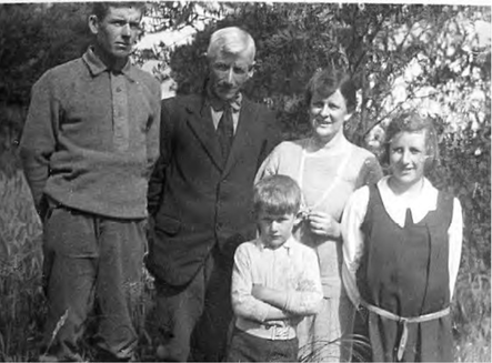
George, Bert, Emily, Gwen, and Thomas Vivian (Viv) Nethercote. Photograph courtesy of Tim Shambrook and Nethercote family. |
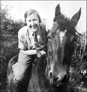
Gwen Nethercote and her horse, 'Lady'. Photograph courtesy of Tim Shambrook and Nethercote family. |
Gerald and Beryl Letts (1940-1987)
The property was acquired from the Nethercote family by Gerald (d. 1987) and Beryl Violet Letts (d. 1972) in 1940, who renamed the house 'Greenways' and maintained the property in prime condition until Gerald's death in 1987 (Shambrook, 2010). The 'Herald Sun' reported the 'Greenways' home was extensively modified during the 1950s (Jolly, 2014).
The property was acquired from the Nethercote family by Gerald (d. 1987) and Beryl Violet Letts (d. 1972) in 1940, who renamed the house 'Greenways' and maintained the property in prime condition until Gerald's death in 1987 (Shambrook, 2010). The 'Herald Sun' reported the 'Greenways' home was extensively modified during the 1950s (Jolly, 2014).
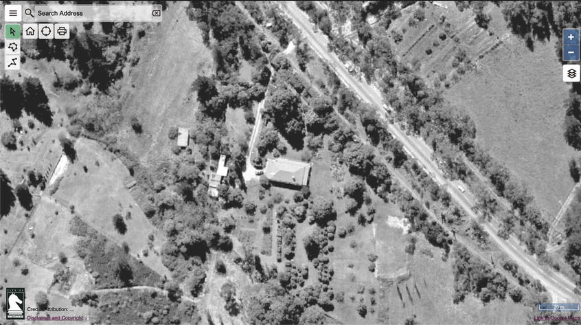
The Nethercote homestead later known as ‘Greenways’ pictured in an aerial photograph from 1963. Boronia Road runs from the top left to the bottom right. The property is estimated to have been built in the late 1880s but was extensively modified during the 1950s. Source: City of Whitehorse.
Later Years (1987-2014)
'Greenways' was subsequently acquired by Vic Roads in 1987 for the Healesville Freeway Reservation (Shambrook, 2010). However, before this it was leased to St. Luke's Church of Vermont for a year by the churchwarden, Len Sixsmith and his wife, and was simultaneously made available for use as a local retreat and respite house for the community. It was later included in a heritage overlay by the Whitehorse Council (Friends of the Healesville Freeway Reserve, 2013).
'Greenways' was subsequently acquired by Vic Roads in 1987 for the Healesville Freeway Reservation (Shambrook, 2010). However, before this it was leased to St. Luke's Church of Vermont for a year by the churchwarden, Len Sixsmith and his wife, and was simultaneously made available for use as a local retreat and respite house for the community. It was later included in a heritage overlay by the Whitehorse Council (Friends of the Healesville Freeway Reserve, 2013).
St. Luke's Church of Vermont brochure to promote 'Weston Favell' as a short-term retreat. Photographs courtesy of Dick Nethercote.
In 2013, some 26 years after Gerald Letts' passing, the original homestead was still standing, however, it had suffered from an extensive period of neglect and was in need of urgent repair (Friends of the Healesville Freeway Reserve, 2013). Whilst the house itself was uninhabited as of 2013, the neighbouring site of the former 'Airlie Vale' poultry farm, was frequently used by numerous individuals as the property offered horse agistment services and accommodated equestrian studies conducted through Box Hill TAFE (Friends of the Healesville Freeway Reserve, 2014). The property was also formerly used for weddings and other events (Friends of the Healesville Freeway Reserve). The 'Nethercote' property was opened to the public for the 'Healesville Freeway Reserve Community Day' held on the 26th May 2013 (Friends of the Healesville Freeway Reserve, 2013).
Tragically, the original homestead was destroyed in a suspicious arsonist attack between 25-26th October 2014 (Friends of the Healesville Freeway Reserve, 2014). The neighbouring 'Airlie Vale' homestead was demolished some years later.
Before its destruction in 2014, 'Greenways' was considered to be the oldest remaining residential dwelling in Vermont and thanks to the efforts of Tim Shambrook and Valda Arrowsmith as members of the Nunawading Heritage Study Steering Committee, the building had been granted a Local Heritage Overlay. Tim summarised his research on 'Weston Favell' in 2014 which included his reflections on speaking to Arthur and Emily Nethercote's daughter, Gwen, in the 1980s about her family's time spent living at 'Weston Favell'.

References
1. Friends of the Healesville Freeway Reserve, 2013, Healesville Freeway Community Open Day - 26th May 2013, viewed 15 July 2020, <http://www.friendsofthehealesvillefreewayreserve.org/17-healesville-freeway-community-open-day-26th-may-2013.html>.
2. Friends of the Healesville Freeway Reserve, 2014, Arson attack on Heritage property on Boronia rd, viewed 15 July 2020, <http://www.friendsofthehealesvillefreewayreserve.org/38-arson-attack-on-heritage-property-on-boronia-rd.html>.
3. Jolly, L, 2014, Greenways heritage site to be preserved as part of Healesville Freeway Reserve plans, viewed 16 July 2020, <https://www.heraldsun.com.au/leader/east/greenways-heritage-site-to-be-preserved-as-part-of-healesville-freeway-reserve-plans/news-story/b3306fe887de2f4ddd2704ae55c903e2>.
4. Nethercote, 2020, Nethercote Horse Agistment, viewed 15 July 2020, <epage.at/nethercote>.
5. Nethercote, Joan, 2000, A Girl's View of Vermont, and a Woman's View of the Second World War.
6. Shambrook, Tim, 2010, This is Vermont: The Green Hill Where I Live, pages 43-44.

