The Hall Family

The Hall family were early settlers in the Vermont area. Charles Dawes Hall was a florist, orchardist and long-term resident of Vermont for over 40 years. Two of his sons, William Kent Hall and Henry Galbreath Hall, were both orchardists and landowners in the Vermont area.
William Kerrison Hall
William Kerrison Hall (b. c.1817-d.1870) was baptised in 1841 at the age of twenty-three. He married Sarah Hassock (b. 1824- d. 1850) with whom he had three children, all of which were born in Hartlepool, England. Sarah died in the period between March 1849 and March 1851, as in the 1851 census, William was listed as a widower.
William Kerrison Hall (b. c.1817-d.1870) was baptised in 1841 at the age of twenty-three. He married Sarah Hassock (b. 1824- d. 1850) with whom he had three children, all of which were born in Hartlepool, England. Sarah died in the period between March 1849 and March 1851, as in the 1851 census, William was listed as a widower.

|
Charles Daws Hall
Charles Daws Hall (b. 1846- d. 1929) was born in Hartlepool, England, to parents William Kerrison Hall (b. 1817-d. 1870) and Sarah Hassock (b. 1824- d. 1850) and emigrated to Australia at age seven in 1853 (Box Hill Reporter, 13 Dec 1929). Charles was a florist and orchardist who eventually settled in Vermont where he lived for over 40 years (The Age, 28 May 1929). In this time, he was elected to the Nunawading Shire Council in 1896 and served as its president from 1899-1900. He also served as a member of the Local Progress Association and as a member of the Mitcham branch of the Dad's Association (Box Hill Reporter, 26 Apr 1929). At the time of his passing in April 1929, he was regarded as "one of the oldest and best known and most respected identities in the district" (Box Hill Reporter, 26 Apr 1929). He was survived for several months by his wife Jane, who also died in 1929 whilst living at the residence "Coolamurt" in Terrara road, Vermont (Box Hill Reporter, 13 Dec 1929). |
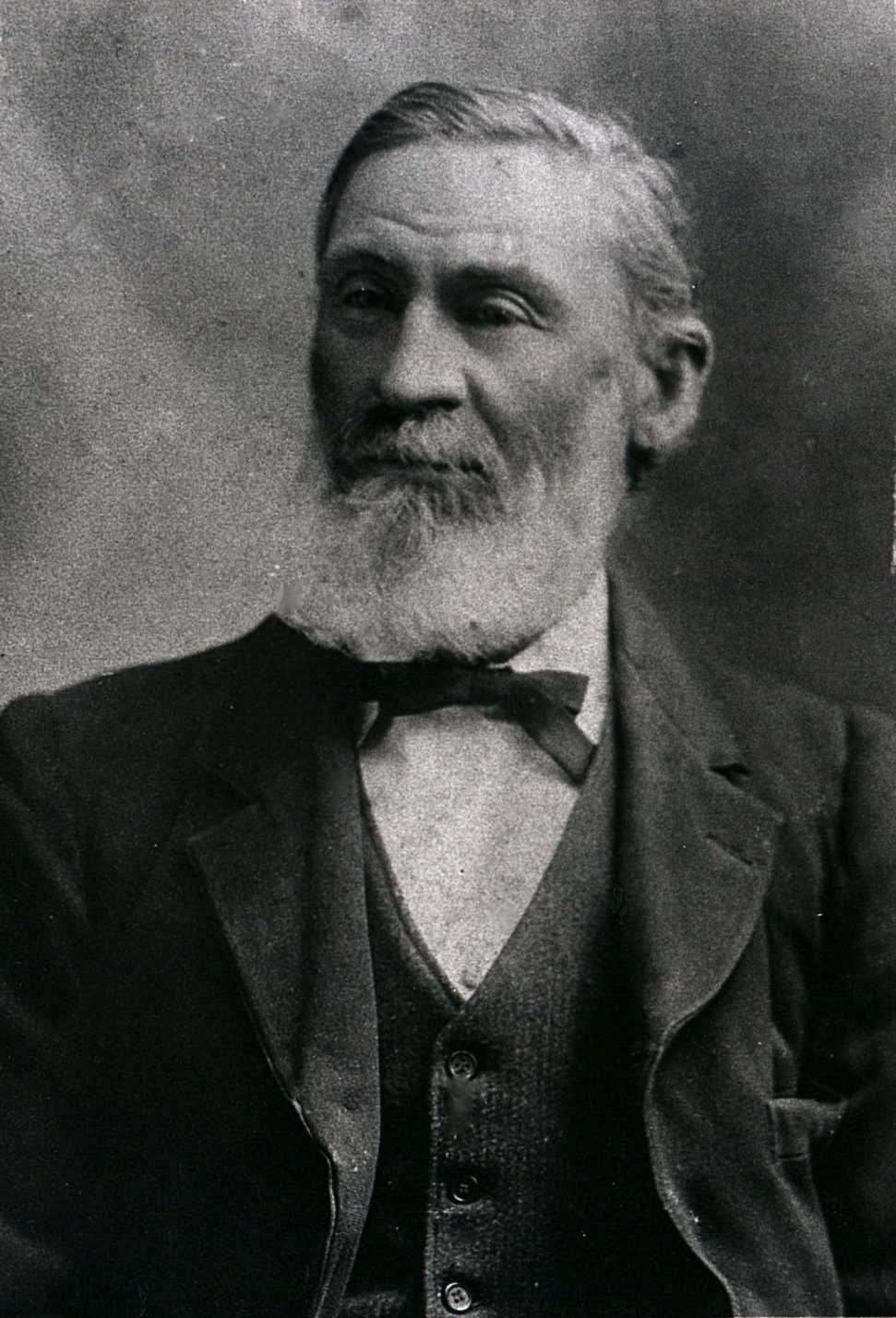
Charles Daws Hall c. 1915. Source: (millers167, 2012) |
Charles was substantial landowner in the area, being the owner of 'Hall's Flower Farm Estates' in Mitcham, which became a collection of subdivided land packages offered at auction on the 13th October 1923 by prominent real estate agents, Coghill and Haughton.
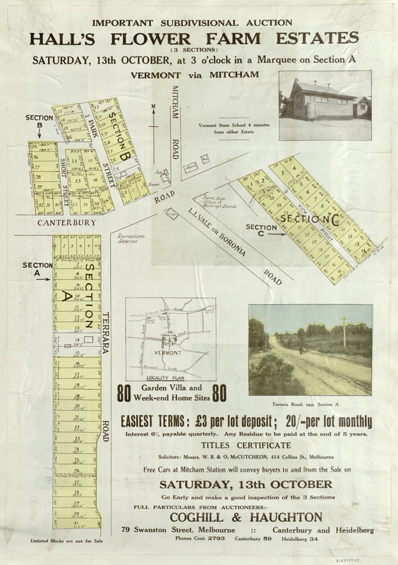
'Hall's Flower Farm Estates', Mitcham, 1923. Source: State Library of Victoria. |

Jane Hall
Jane Hall (nee Scammell) (b. 1860- d. 1929) was the wife of Charles Daws Hall and a long-term resident of Vermont, Victoria. Jane was "well known in the Vermont district" where she was remembered as an "active church worker" with a "keen interest in local affairs" (Box Hill Reporter, 13 Dec 1929). She passed away in 1929, several months after the death of her husband, whilst living at the residence "Coolamurt" in Terrara road, Vermont (Box Hill Reporter, 13 Dec 1929). Together, Jane and husband Charles had ten children: William Kent (b. 1881-d. 1955), Henry (Harry) Galbreath (b. 1883-d. 1954), Annie Wilmot Peggie (nee Hall)(b. 1885- d. 1946), Frances Jane (b. 1886-d. 1949), Lucy Kirkpatrick (nee Hall) (b. 1888-d. 1966), Athena May (b. 8th October 1890-d. 21st July 1923), Charles Samuel (b. 1893- d. 1917), Walter Hastings (b. 1896-d. 1970), Hannah Ivy Miriam (b. 1899-d. 1977) and Ruth Isabel (b. 1901-d. 1981) (Box Hill Reporter, 26 Apr 1929). Of her ten children, sons William and Henry, and daughters Hannah and Ruth resided in Vermont. Hannah married Esmond Eric Connolly in 1922 and the couple lived in Vermont until very late in her life. Hannah and Esmond's residence is presumed to be indicated as the untainted blocks in Section B of the above map of the 'Hall's Flower Farm Estate'. Ruth married Travers Melford in Balaclava in 1934 after which it is believed that the couple moved away from Vermont.
Jane's nephew, Charles Howard Scammell, is listed on the Vermont World War I Honour Roll, which may indicate that he was staying with the Hall family at that time.

William Kent Hall
William Kent Hall (b. 1881-d. 1955) was the eldest son of Charles Daws Hall and Jane Scammell. At the time of his father's death in 1929, for which William was an informant, his recorded occupation was a storekeeper. William later acquired a 12.5 acre property in Boronia Road, Vermont, situated in-between the Nethercote property and the Dandenong Creek. During this time, William worked on the neighbouring Livermore orchard located toward Morack Road. Sometime around 1940 or slightly later, William planted an orchard on his Boronia Road property. He also grew flowers. William married in 1942 and later served in World War II from 1943. William's wife and her sister tended the trees whilst William was away on military service.
William Kent Hall (b. 1881-d. 1955) was the eldest son of Charles Daws Hall and Jane Scammell. At the time of his father's death in 1929, for which William was an informant, his recorded occupation was a storekeeper. William later acquired a 12.5 acre property in Boronia Road, Vermont, situated in-between the Nethercote property and the Dandenong Creek. During this time, William worked on the neighbouring Livermore orchard located toward Morack Road. Sometime around 1940 or slightly later, William planted an orchard on his Boronia Road property. He also grew flowers. William married in 1942 and later served in World War II from 1943. William's wife and her sister tended the trees whilst William was away on military service.

Henry Galbreath Hall
Henry Galbreath Hall (b. 1883-d. 1954) was a retired orchardist who resided at his residence, 'Coolamurt', in Terrara road, Vermont. Henry married Theresa Ann Chalmers (d. 1944) and their eldest daughter, Mavis Maud Hall, continued to live in Terrara Road, Vermont, until her death in 1979. In 1918, Henry was registered as the owner of the 14-acre 'Mitcham South Estate' (Gilfedder et. al, 1992).
Henry Galbreath Hall (b. 1883-d. 1954) was a retired orchardist who resided at his residence, 'Coolamurt', in Terrara road, Vermont. Henry married Theresa Ann Chalmers (d. 1944) and their eldest daughter, Mavis Maud Hall, continued to live in Terrara Road, Vermont, until her death in 1979. In 1918, Henry was registered as the owner of the 14-acre 'Mitcham South Estate' (Gilfedder et. al, 1992).

Charles Frederick Hall
Charles Frederick Hall (b. 1917-d. 1979) was the son of William Kent Hall and his first wife, Ruth Enid Johns (b. 1917-d. 1952). He built a home on his family property in the early 1950s some distance away from the original house occupied by his father, William Kent Hall. The house of William Kent Hall; which already existed prior to its acquisition by the Hall family, may have been built in the 1920s based on newspapers dated from that era which were used as lining behind the board of the kitchen and were discovered when the house was demolished (Alan Hall, personal communication 5th June 2022). Charles also developed an orchard on part of the property between his father's house near the Dandenong Creek, and the land bordering the Nethercote family's property. Charles also acquired property of approximately 2 acres in size from the neighbouring Livermore orchardist family on which he built a cool store and garage on the property (Alan Hall, personal communication 5th June 2022).
Charles Frederick Hall (b. 1917-d. 1979) was the son of William Kent Hall and his first wife, Ruth Enid Johns (b. 1917-d. 1952). He built a home on his family property in the early 1950s some distance away from the original house occupied by his father, William Kent Hall. The house of William Kent Hall; which already existed prior to its acquisition by the Hall family, may have been built in the 1920s based on newspapers dated from that era which were used as lining behind the board of the kitchen and were discovered when the house was demolished (Alan Hall, personal communication 5th June 2022). Charles also developed an orchard on part of the property between his father's house near the Dandenong Creek, and the land bordering the Nethercote family's property. Charles also acquired property of approximately 2 acres in size from the neighbouring Livermore orchardist family on which he built a cool store and garage on the property (Alan Hall, personal communication 5th June 2022).
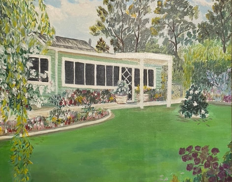
The Hall family home built in stages during the early 1950s by Charles Frederick Hall. Painting courtesy of Charles' son, Geoff Hall. 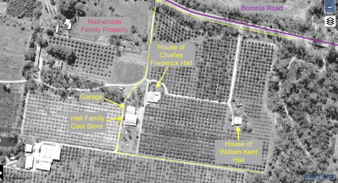
|
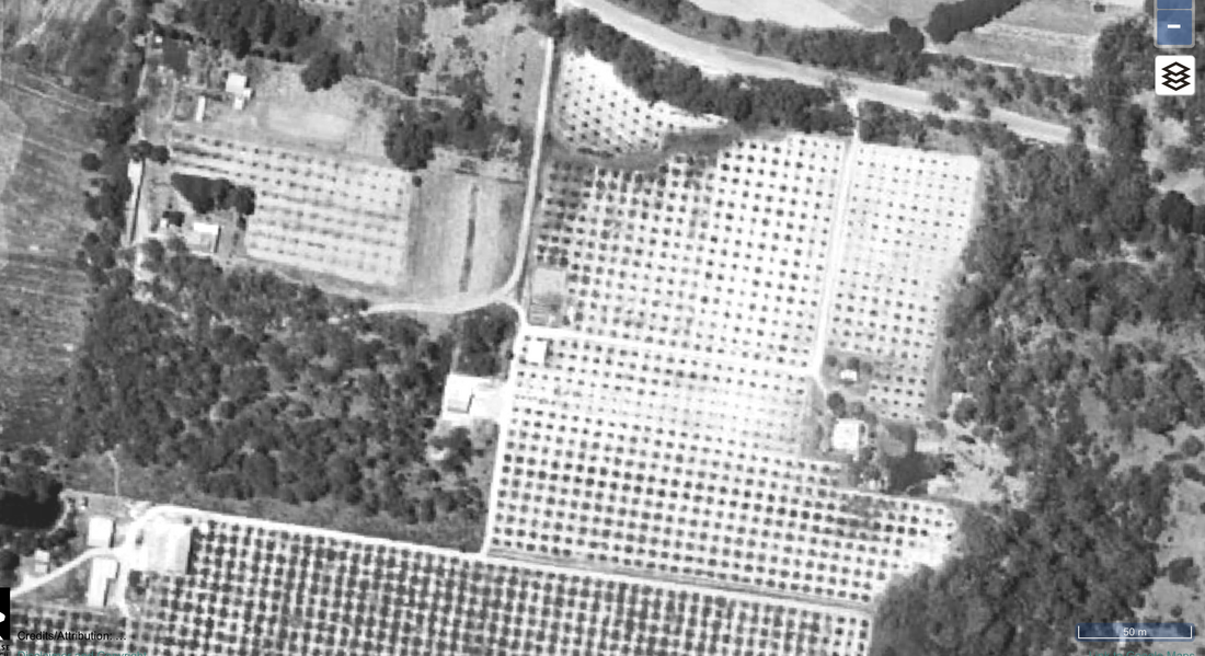
The Hall family property pictured in 1963. Boronia Road runs left to right along the top of the image. The Dandenong Creek demarcates the eastern boundary of the property. Labelled are the houses of Charles Frederick Hall and William Kent Hall.
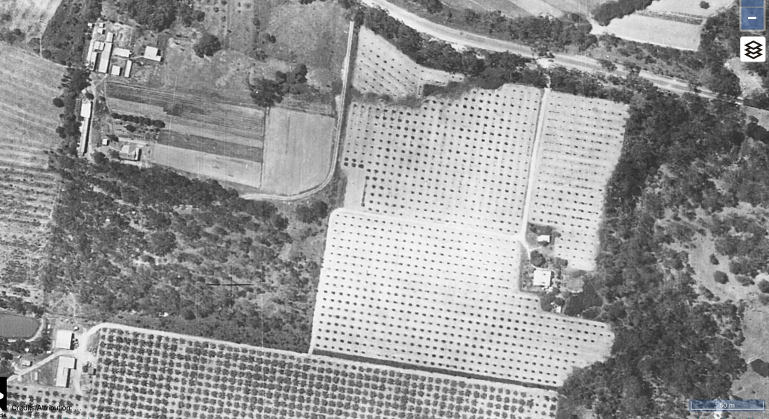
The Hall family property pictured in 1945. Boronia Road runs left to right along the top of the image. The Dandenong Creek demarcates the eastern boundary of the property. 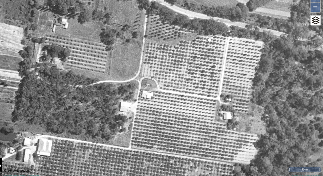
The Hall family property pictured in 1956. Boronia Road runs left to right along the top of the image. The Dandenong Creek demarcates the eastern boundary of the property. 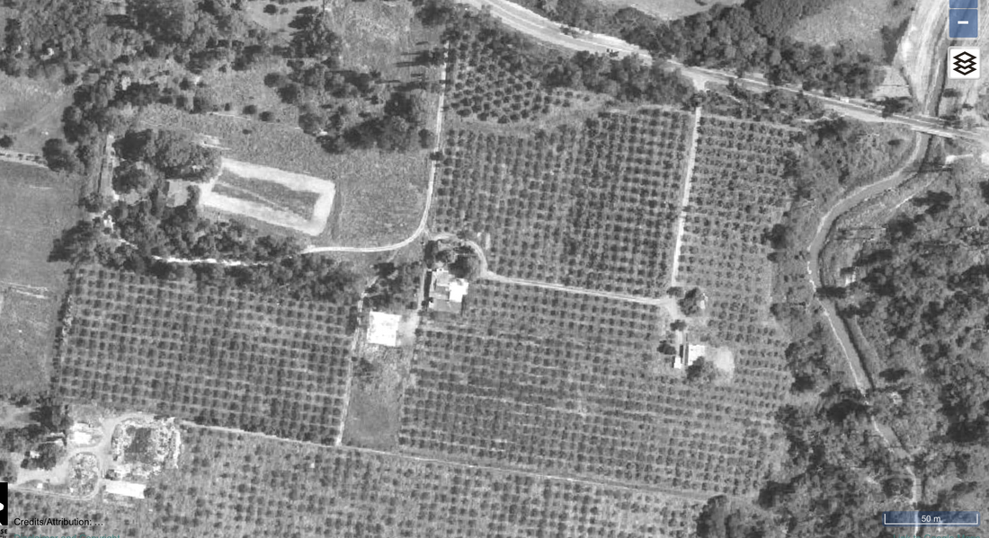
The Hall family property pictured in 1975. Boronia Road runs left to right along the top of the image. The Dandenong Creek demarcates the eastern boundary of the property. |
The Hall family property pictured in 1951. Boronia Road runs left to right along the top of the image. The Dandenong Creek demarcates the eastern boundary of the property. 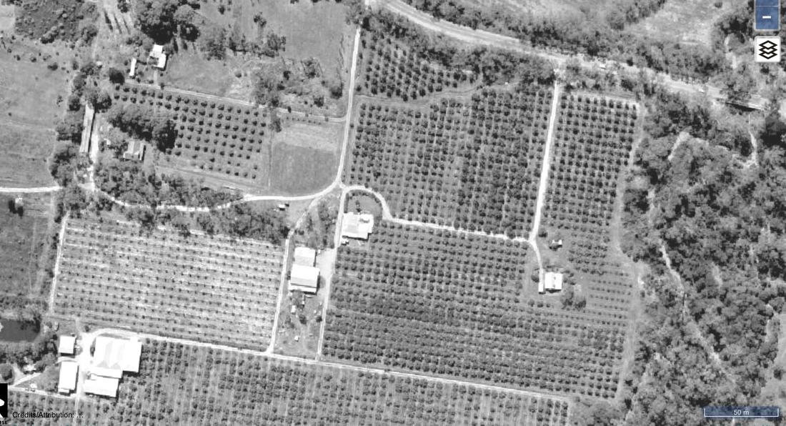
The Hall family property pictured in 1963. Boronia Road runs left to right along the top of the image. The Dandenong Creek demarcates the eastern boundary of the property. 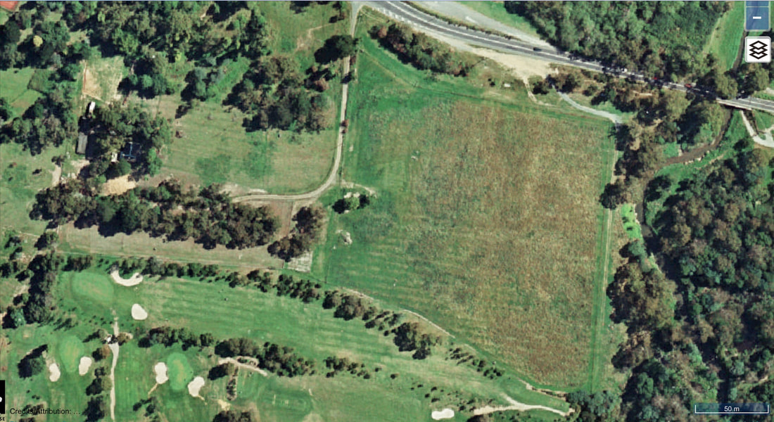
The Hall family property pictured in 1996. Boronia Road runs left to right along the top of the image. The Dandenong Creek demarcates the eastern boundary of the property. |

References
- Gilfedder, F, McConville, C, Butler, G 1992, 'Strathdon Nunawading Historic Orchard Conservation Analysis', viewed 3rd June 2020, <https://www.academia.edu/40237602/STRATHDON_NUNAWADING_HISTORIC_ORCHARD_CONSERVATION_ANALYSIS>.
- Hall, Geoff, 2022, Personal communication.
- millers167, 2012, Charles Dawes Hall, viewed 27 July 2020, <https://www.ancestry.com.au/mediaui-viewer/tree/44281161/person/132093192260/media/16c0c32e-cbc7-43dd-9e11-ab0829beb93e>.

